
South Carolina Map
|
 |
 |
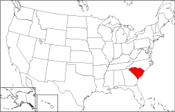
Where Is South Carolina?
The State of South Carolina, highlighted in red on this map, is bounded by North Carolina on the north. It is bordered by the Atlantic Ocean to the southeast, and by Georgia to the southwest.
South Carolina Maps
The State of South Carolina is the 40th largest state in the United States, and its land area is 30,109 square miles (77,982 square kilometers). The state has 46 counties. This South Carolina map site features road maps, topographical maps, and relief maps of South Carolina. The detailed, scrollable road map displays South Carolina counties, cities, and towns as well as Interstate, U.S., and South Carolina state highways. The pannable, scalable South Carolina street map can be zoomed in to show local streets and detailed imagery.
South Carolina Highway Map Click on the highway map thumbnail
to view a scalable South Carolina road map. |
SC Topo Map Click map to enlarge.
|
SC Relief Map Click map to enlarge.
|
The detailed South Carolina map and the regional South Carolina map display cities, roads, rivers, and lakes as well as terrain features. The detailed map shows only the State of South Carolina, while the regional map shows South Carolina and the surrounding region.
South Carolina Infrastructure > South Carolina Airports
In 2005, the population of South Carolina was estimated at 4,246,933, which is about 141.3 people per square mile. In 2010, South Carolina's population rose to 4,625,364 people. More recently, in the 2020 census, the South Carolina population was 5,118,425. The state's Interstate Highways include I-20, I-26, I-77, I-85, and I-95.
South Carolina Topography
South Carolina was named in honor of King Charles I of England. Its terrain rises from swampy coastal plain in the southeast to the Piedmont's rolling hills, then up to the Blue Ridge Mountains in the northwest. The region is drained by numerous rivers, including the Savannah River along the southwestern border. Coastal resort towns such as Myrtle Beach and Hilton Head attract beachgoers, golfers, and tennis players, while Fort Sumter National Monument and Cowpens National Battlefield are important historic sites. Visit the official South Carolina tourism site and South Carolina Atlas for South Carolina travel and tourism information.
Other Maps of South Carolina
This South Carolina reference map shows major cities, roads, railroads, and physical features in South Carolina.Several map publishing companies offer printed maps of South Carolina. For example, Omni Resources offers several maps of South Carolina that feature points of interest, airports, and parks, as well as selected local attractions and insets of major South Carolina cities.
All rights reserved.
Certain maps hereon are © Map Resources or Digital Wisdom.
To facilitate browsing, certain external links will open in new windows.
South-Carolina-Map.org Editor, State Maps, PO Box 828, Barnegat, NJ 08005.